Points
Points are used to define the basic
geometry of the structure or model. This includes columns, beams, walls,
and slab edges. Points are also used to define load locations such
as point loads, line loads, and area loads. Each Point is a point
in space defined by coordinates in the horizontal and vertical directions or axes. Each
floor level will have its own unique points.
Points are created automatically as
you draw, but may be created manually from within the Point Locations Spreadsheet.
Once created, either automatically or manually, the points may be edited within this spreadsheet.
- Select the Point
Locations Spreadsheet from the Spreadsheets Menu and
define the point
coordinates.
- You may use cut and
paste, block fill, and block math to enter and edit points.
- You may choose the
prefix that is used to label the points.
- Select
the Tools Menu and choose Round Off Joint Coordinates.
- This utility will
round off all the joint coordinates to 1, 2, or 3 decimal places (user
selected). This sometimes is useful for models that have been generated
or created via DXF import and have joint coordinates with a large number
of decimal places that aren't significant. Rounding off those coordinates
makes the data more consistent and can help avoid problems such as non-coplanar
plate/wall joints. Also,
the default member orientations can change based on whether the member
is exactly parallel to a global axis and slight unintended coordinate
differences can have an impact here as well.
Point Locations Spreadsheet
The Point Locations Spreadsheet
records the labels and coordinates for the points and may be accessed
by selecting Point Locations on the Spreadsheets Menu.
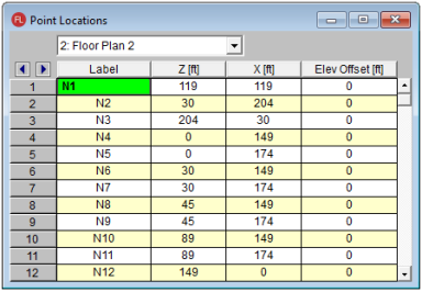
The pull down list at the top of the
spreadsheet allows you to toggle between floors.
Use the first column to assign a Label for each point. You can then refer to each point by its label. Each
label has to be unique for that floor level. If you try to enter
the same label more than once you will receive an error message.
As you create new lines, the program will automatically create a new,
unique label for each point.
The next two
columns contain the coordinates of the point in theZ direction, or horizontal and the X direction or vertical directions. These represent the offsets of the points from the origin
of the coordinate system (0, 0). The appropriate units are listed
at the top of each column.
The last column contains Elev Offset. The elevation of the point is referenced for the floor level. If you enter a number larger than zero, the floor will be sloped.
Note:
- Only the points located at supports can have an Elevation Offset larger than zero
- The Elevation Offset value can not be entered into the spreadsheet negative. If a negative value is calculated for a cantilever, the value cannot be manually adjusted.
- Only the top floor level in the model is allowed to have an Elevation Offset larger than zero. This feature is meant for the use of sloping roofs.
Point
Joint Information Dialog
Just as with the members and plates
you
You may double-click any pointjoint to view it’s properties. All
of the same information that is stored in the Joints Points spreadsheet
is displayed for the pointjoint you choose, and may be edited. This is
a quick way to view and change pointjoint properties. For large selections
of pointsjoints however the spreadsheet and graphic editing tools may be the
faster solution.
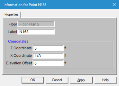
Floor - This reports which floor level the point is located on. It is not editable in this dialog.
Label
- You can view and edit the pointjoint’s label.
Coordinates
- You can view and edit the pointjoint coordinates.
Elevation Offset - You can view and edit the vertical elevation offset (for points on sloping floors). This is only available on the top-most floor level.